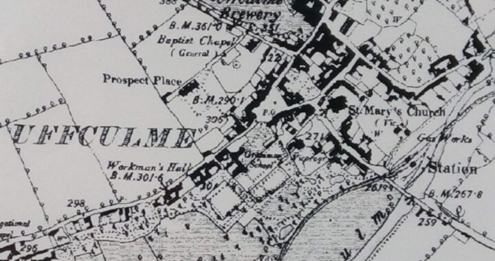
Walks Round Uffculme – Itinerary 1
The Old Village
For Heritage Open Days in 2019, we produced a couple of walking itineraries around Uffculme both for visitors not familiar with the village and for local people who want to pick up on some of the historical details which they haven’t noticed properly before. This walk starts in the churchyard of St. Mary’s parish church. A history of the church can be found in a separate article on the website.
Coming out of the church porch, turn left and follow the path to the back of the churchyard. As you approach the back gate, notice the two the big yew trees to the left and right. One is believed to be around 200 years old and the other is thought to have been planted in 1910 at the accession of George V. Although there are relatively few gravestones left in the churchyard, thousands of people have been buried here over the centuries. A plan of the churchyard has been created (and can be found elsewhere on the website) and gives a sense of just how many people rest here.
[There are steps at the back and front porches to the churchyard. To avoid these turn right out of the church porch and follow the – slightly uneven – path inside the churchyard wall. Turn right into Fore Street and go along to the junction with Kents Close, half way along to the right to pick up the walk.]
At the ‘back door’ lychgate, turn left up Kents Close. Much of the land on which the more modern houses of Kents Close now stand was once a market garden. There are still some small allotments tucked between the high wall and one of the newer houses.
You’ll reach the junction with Fore Street where you can see several houses with frontages that were once shops – this was a busy street with a lot of shops and was one of the main roads of the village in previous centuries. The 1840 circular map of Uffculme shows that this was once called Queen Street. Turn right out onto Fore Street from Kents Close. The last three houses on the left were once all part of Brook House (notice on number 15 there is a stone plaque above the first floor windows ‘James and Susannah Brook 1732’).
At the junction with Kitwell Street/East Street take a left turn if you want to follow this shorter walk (just over half a mile), or turn right for the longer walk (see separate article – a little over a mile).
The Shorter Walk
Turning left (into East Street from Fore Street), past Brook House, you will see the next house on the left a little way up that was a bakery. Just beyond on the left are the modern metal gates that mark the Furze Brewery of 1858 and the remains of the huge brewery building (now in private residential ownership). There’s an article on the Furze Brewery on the History Articles page of the website. On the right is a cottage still called ‘Old Brewery Cottage’.
At the junction with High Street, if you cross the road, from the pavement opposite the brewery you can see a bricked-up doorway between the 2nd and 3rd floors that was the entrance to the walkway which once linked that side of the brewery to other buildings across the High Street (now demolished and a small block of flats built on the site). [No dropped kerb on this section of pavement.] Before you leave that area, go a few yards to the right and you’ll see ‘Farmers’ (now a private house), on the corner of Clay Lane, which at one time was one of the many pubs in Uffculme. A small window in the house just inside Clay Lane reveals part the 16th century wooden mulllions which were an original feature of the property. It is believed to be one of the oldest buildings in Uffculme (though of course much altered).
Returning to High Street and the brewery, continue along towards The Square. Note London Inn Court on the left hand side which was once the London Inn pub (with bottle ends embedded in one wall) – another pub and former coaching inn (the archway to the courtyard beyond is still there). Another house on the left is called ‘The Stables Cottage’ and was the site of the stables of the London Inn.
Continue a little way along to the bottom of Chapel Hill – the Baptist Chapel (rebuilt in 1815), a short distance up the hill, gives the road its modern name. It was once called Connegar, Conacre or Cuniger Hill in reference, it is thought, to ‘coney’ the old word for rabbit. The name connegar is often associated with a mound built for the farming of rabbits. The old name was in common use until the 1920s.
At the bottom of Chapel Hill are several original plastered cob and rubble cottages thought to date from just after 1700. One towards the top of the group is of unfaced sandstone, hence called Stone Cottage. The junction was widened in the 1970s when a section of the land belonging to the then owner of 7 High Street, Arthur Hellier, was bought by the County Council to make the junction more accessible to school buses going up to the secondary school further up Chapel Hill.
‘The Old Butchers’ opposite the end of the junction (now run as a craft activity centre) was formerly Williams the butcher’s shop. Continue along High Street to reach The Square where you will see the Shambles (a covered market ‘bench’ – it is believed that markets and fairs took place in the Square from at least the 13th century right up until 1916, with the Shambles being a focal point for transactions, particularly meat sales, although the present structure has been much restored over the centuries). There’s an article on the Shambles on the website. With the number of cars now having to use the Square, it’s a very different place from earlier days but it’s possible to see the various buildings which were once shops – and some are still in use. A cafe at number 11, Square Corner (a church-owned community and activities centre) and the general store (for over a century a Co-Operative Society shop and only recently changed to a Nisa store) are all that remain of the many shops (and banks) which were once in The Square.
Cross the road by the Ostler (formerly the Commercial Inn) and cut across the grass behind the bus stop. You’ll see the building in front of you which was once Ayshford Grammar School, endowed in 1701 – the school bell, given by J.W. Clarke of Bridwell, is now in the courtyard in front of the flats and a bell tower remains on the building. Ayshford started life as a school and has also been a children’s home. It is now divided into flats. The plaque commemorating its founder, Nicholas Ayshford, is still to be seen on the wall.
Turn left after you’ve crossed the diagonal path past Ayshford (ground that was originally part of the school), continue through the small car park and turn left onto Markers Road. There’s now an older people’s housing complex in this area, which was named after a prominent local family. Notice the two enormous Sequoia trees on either side of the road which are likely to have been planted in the late 19th century when the trees started to be imported to Britain and it was fashionable for large estates to plant them. Continue straight down the road (a cul de sac) and take the path across the grass at the end of the buildings, crossing a small wooden bridge over the stream. [No dropped kerb where the road meets the path before the wooden bridge.] The surfaced footpath in front of you is the line of the old Culm Valley Light Railway line which runs half a mile along to the right Coldharbour Mill. The railway ran between Tiverton Junction and Hemyock (site of a major dairy). There’s an article on the Culm Valley Light Railway on the History Articles page of the website.
Looking to your right you will see, a short distance along, crossing the leat, a metal bridge that was part of the original railway line.
Turn left along the path with the feed mill fence to your right and continue to the end of the path, where there is another wooden bridge by the pond. Keeping right at the green will bring you along the side of the ‘Garden Room’ (a more modern extension to the Village Hall) and the Village Hall itself. This was formerly called the ‘New Room’ when it was built in 1888 to celebrate Queen Victoria’s jubilee. The path brings you out at the side of the Village Hall, a short distance down Bridge Street from St Mary’s Church where you started your walk. As you cross the road, notice the white house (now Bridge Cottage) above the village hall – this was part of the workhouse from the late 18th century for over 100 years, likely the workhouse keeper’s house when the workhouse was on the site of the Village Hall, and later the workhouse itself when less room was needed.
Before arriving back at the church, if you look down Bridge Street (to your right) you’ll see the brick bridge over the river Culm (rebuilt in 1876 at a cost of £500), just after the Station Garage and what is now the feed mill. In earlier times that was an abbatoir, conveniently situated near the railway line. The road opposite (Denner’s Way) is the former site of Uffculme Station.
[With thanks to John Bell, a very long serving member of Uffculme Local History Group and now its president, for a wealth of information particularly from his notes about street and house names.]
Please let us know if you have any interesting bits of historical information to add to this walk itinerary!